
INSIDE TO ALASKA

GETTING READY TO GO
There are two ways to take the Inside Passage: in quick spurts or in slow, steady runs. The first method requires a fast, planing hull that can make 20 to 35 miles an hour in calm water. The best choice here is an outboard cruiser at least 20 feet long or an inboarder of 25 feet and up. A planing boat, in a normal day's run, covers 60 to 140 miles in three to five hours, and the rest of the time is yours to fish, explore and take pictures.
The steady-run technique makes use of the slower displacement hull which pushes water aside rather than planing over the top of it. The slow and steady yachtsman makes only six to 10 knots through the water and may take as long as seven to 10 hours to get from one gas stop to another. On the other hand, a displacement boat shakes less in choppy water, and its crew arrives on the scene fresher than the planing-hull contingent.
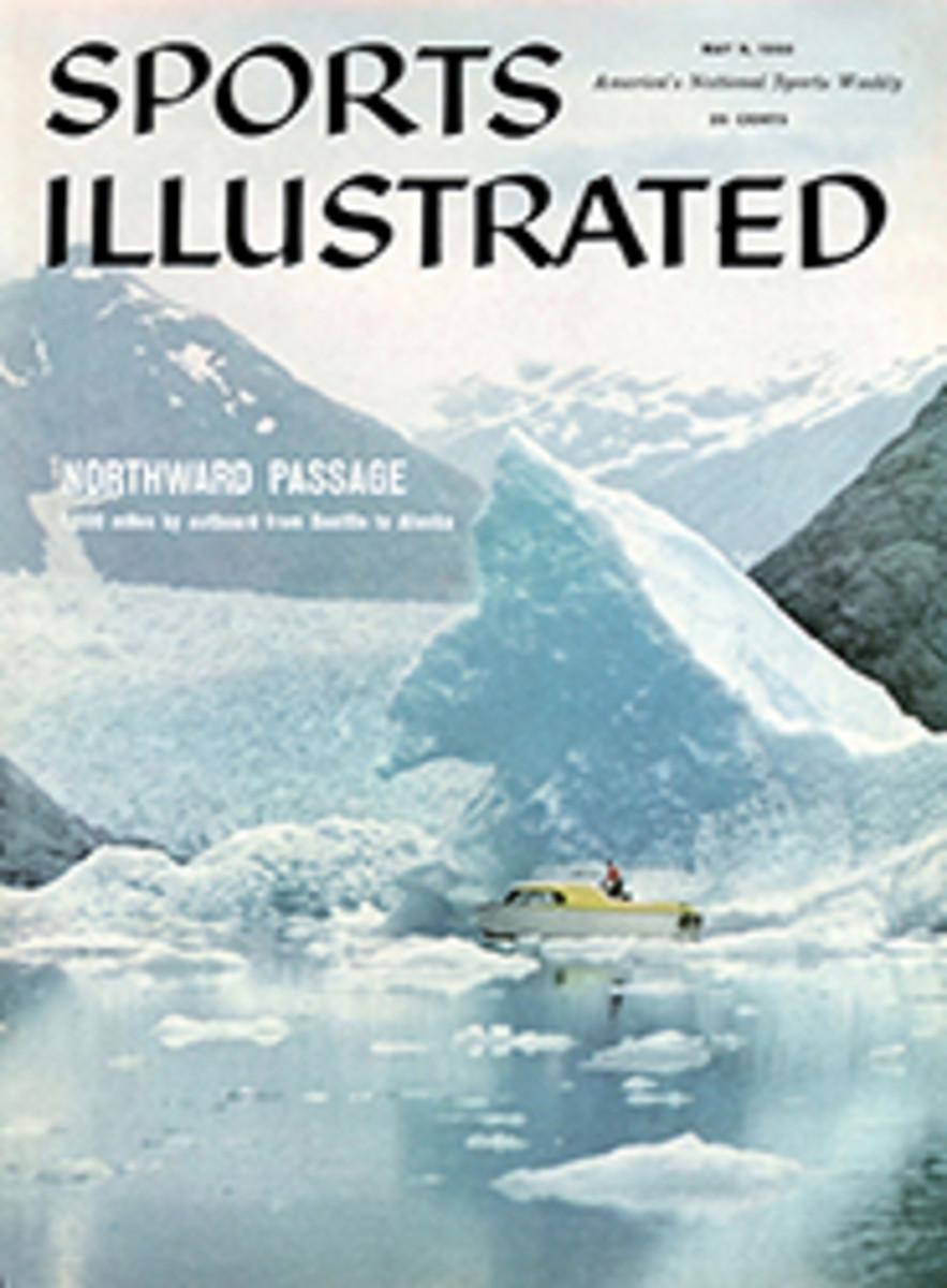
Sports Illustrated selected its 24-foot Norseman outboard cruiser (see cover) for two reasons. One was her comfortable size—24 feet in an outboard hull gives you almost as much usable room as a 35-foot cruising sailboat. A smaller boat would have been uncomfortable for our three-man crew, and a larger boat would have given us room we didn't need. We also picked her for her sound construction, a vital factor in the Inside Passage where, in spite of sheltering mountains, the water is seldom calm. The wind blows up the narrow passes or it blows down them, setting up a short chop which can cut your speed to less than eight knots. Aboard our Norseman, we found that we could run at top cruising speed—35 miles an hour with twin 60-hp Mercury outboard engines—only about a third of the time, which was still enough to keep our average speed high.
But whether you take it fast or slow, the Inside Passage is no cruise for a careless yachtsman. There are a number of open stretches, and crossing them demands judgment and timing. The frequent heavy rains and mists along this coast can add further to the hazards of navigation. Fitting out, proper tuning and judicious choice of equipment are all-important.
Seattle, a city almost surrounded by water, has the best fitting-out facilities north of San Francisco. For this reason and also for the hospitality shown to cruising men in this bustling boating center, most northbound yachtsmen do their launching and fitting out at one of the more than 60 marinas that finger into Lake Union, Lake Washington and Puget Sound. For the outboarders, marinas like Bryant's (Evinrude) and Pacific Fish and Trading (Mercury) can rig, launch and tune your boat in a single day. Inboarders can pick from among half a dozen outstanding marinas, the best-known being Marine Charters, run by Norman Ledger. If you have no boat of your own, Ledger can arrange to charter one for you for the whole Alaska cruise.
Once your boat is ready to go, plan to spend at least a day in trial runs on the lakes or out in Puget Sound. In these final stages of preparation, keep the following points in mind:
•No boat going very far north of Seattle should venture forth with only one engine at its disposal. Outboard cruisers should carry a second engine, even if it is only a 15-hp kicker for fishing. Twin outboards with 25 hp or more apiece are an even better bet. Only if you are traveling with another boat should you risk the trip with just one engine—and even then, hold a close formation.
•A dinghy makes your trip much more fun—you can anchor out and row ashore for swimming and cook-outs, but for emergency situations each yacht should carry an inflatable rubber raft tied to the cabin top when crossing open stretches.
•An electric windshield wiper and a pump to spray water on the windshield and wash the salt off are important safety devices. Rain or salt spray can cut visibility to zero in no time.
•A radio should be carried aboard and kept tuned to the Alaska and Canada weather bands. When you have 20 to 60 miles of unprotected running, you want to know if it's going to be blowing out there.
•Your navigational needs are met by the Northwest Marine Atlas plus Hydrographic Office and U.S. Coast and Geodetic Survey charts (all available at Bryant's Marina).
The basic cruise outlined by SPORTS ILLUSTRATED on the map at left and in the following pages carries you to Alaska and back on a three-to-four-week vacation. The time to start is during the last two weeks of July; June is the rain month, and the big runs of sockeye and silver salmon usually do not start until mid-July.
Hunters may try for bear in the great grizzly country up north, but you may find that mounting an expedition inland from a small cruiser is impractical. If you want to try it, get a license in advance from the Canadian Game Commission.
If the weather stays good, you can do the full cruise in a three-week vacation—16 days up and six or seven going back. If the weather closes in, the trip will take at least another week. The man with a two-week vacation can turn around just south of Alert Bay (see map) and, as Part I of Inside to Alaska shows, still will have had a crack at some of the most exciting cruising on the North American continent.
SEATTLE TO BIG SUCIA
Whether you are going to British Columbia's marvelous fiords or to an Alaskan adventure beyond, one rule applies: start early. Leave Seattle on a course of 340 as marked in your Marine Atlas. Run inside Whidbey Island 75 miles to Deception Pass, a spectacular narrows where the tide will be boiling through at four to eight knots. From there it is 32 miles northwest to Big Sucia in the San Juan Islands, the highly prized vacation grounds of Northwest yachtsmen, and a natural first stop on your cruise.
At Big Sucia, all of the pleasant diversities of the San Juans are represented. Its best anchorage is Fossil Bay, named for the delicate fossil shells that can be found in the crumbling slate outcroppings ashore. On both sides of the state wharf at the ap ex of the harbor the land has been cleared for cookouts and camping. The beach offers clams for the digging, the woods blackberries for the picking, and the harbor crabs for the netting. When you have gathered these treasures, put the clams and crabs to boil over a shore fire and set the blackberries to soak in cream. Then you can eat, relax and consider your next move.
There are 172 islands in the San Juans, and you could easily spend your entire vacation going from one to another. Here are a few of the abundant possibilities:
Waldron Island, five miles southwest of Big Sucia, has excellent salmon fishing. Local fishermen troll with about 60 feet of steel Monel line weighted with a six-ounce sinker. For a lure they bait a spoon with a strip of herring cut diagonally so it spins. A little patience ought to get you a six-or eight-pound silver salmon for lunch.
San Juan Island, 20 miles from Big Sucia, has a fine hotel at Roche Harbor with swimming pool, tennis and horseback riding. The elegant marina welcomes yachtsmen even if they do no more than take on water for the next hop. Friday Harbor, on the east side of the island, is a picturesque waterfront village with good stores manned by tradesmen who like to oblige sailors (not always the case elsewhere in the San Juans). At Friday Harbor there is also a local sport which deserves some mention. The island is overrun with Flemish rabbits, and Roy Franklin at the office of Island Sky Ferries at the airport can put you in touch with the proper parties for an evening of chasing rabbits into a net by flashlight. It is an odd, exhausting, but always exciting sport, and the rabbits make good stew.
Stuart Island, 15 miles away, offers a lovely, secluded anchorage reached by threading through the narrow entrance at Prevost Harbor. Once past the inlet, you will find yourself in a millpond of a harbor with clear deep water and excellent holding bottom. The scenery of Prevost is as good as any in the islands. When the moon comes out full, a world of dark water, forest and glistening rock comes alive in the soft summer air.
SIDE TRIP BELLINGHAM. If, while you are nosing around the San Juans, you feel the need for a final check of your engines, hop over to Bellingham, 40 miles east. The mechanics at Bellingham Marine are fast and good. There is a second good reason for putting in at Bellingham: to talk to Phil Portrey who runs the Axton Road Mobil gas station. Portrey has gone to Alaska twice by outboard, and he has explored the Northwest coast thoroughly. He guided the SPORTS ILLUSTRATED cruise and is an expert on all phases of the trip. Another Alaska veteran, Clyde Banks of the Banks Camera Shop, who took the pictures for this article, is equally informative. And if you have to wait a day for engine repairs, you can drive a Hertz car out of Bellingham to Heather Meadows at Mt. Baker in two hours. There you can rent skis for some of the finest summer skiing in the world.
BIG SUCIA TO NANAIMO
Leaving the San Juans, you have a choice of routes to your next destination, Nanaimo, 52 miles away and the last big (pop. 12,705) city for almost 500 miles. You can go direct, or you can head south for Victoria to take in this delightful outpost of the British Commonwealth.
SIDE TRIP: VICTORIA. Victoria, the capital of the Province of British Columbia, is only 50 miles from Sucia and all that a provincial capital, formerly a colonial outpost of the Empire, ought to be: civilized, planted with flowers and refreshingly slow-paced in a true colonial manner. Victoria is also your first Canadian port. The ship's captain must present himself at the customs office properly identified through a driver's license or other papers and list his passengers and the serial numbers on the cameras aboard. He must deliver up all his guns to be sealed unless he previously has made arrangements with the Canadian Game Commission by mail for a license to hunt specific game.
The place to stay in Victoria is the Empress Hotel, a huge stone pile that dominates the waterfront. Behind its ivy-lined walls are dining halls and reception rooms bigger than the waiting room of a metropolitan train station. The bellboys in attendance are not bellboys, but old and faithful retainers. Upstairs in the rooms, the beds are four feet off the floor on good oak legs, and although the old bathtubs have been replaced by glass-door showers, the telephone service is still distinctly Victorian. The place to eat in Victoria is the Princess Mary, an old coast steamer permanently dry-docked a short way off the waterfront. The refurbished hull now contains one of the best sea food kitchens on the West Coast.
The morning after a stay at the Empress, hire a car and motor up Marine Drive past a lovely parade of homes and flowers—hollyhocks and ivy flung with calculated abandon over wall and lawn, pale yellow hedges set in purple bush, bronze-leafed trees and white, flower-covered arches over the doorways. Thirteen miles north of the city is Butch-art Gardens, a stroke of philanthropy by a man who, having dug a big hole in the countryside to quarry limestone, decided to make the landscape presentable again. The former quarry is now the extraordinary Sunken Garden. There are also a small but brilliant rose garden, a miniature formal Italian plot and a Japanese water garden. In the middle of all this, you will find a tiny and very English restaurant which serves fresh raspberries with cake or ice cream or both, and—crumpets.
SIDE TRIP: OLYMPIC PENINSULA. Across the Strait of Juan de Fuca from Victoria lies Port Angeles; behind it, only 25 miles up Heart O' The Hills Highway, is a world of snow, forest and mountain known as the Olympic range. Ride a ferry over, rent a car, and 15 minutes after leaving the ferry you will be winding upward past great, symmetrical fir trees 60 or 70 feet high, while below, row upon row of forested ridges cascade into valleys way, way down. Then the whole Olympic range comes into view: pile on pile of dark green, relieved by the softer green of mountain moss. Beyond the green peaks are the snow-peak lines, one after another, white and cool, edging far back into the peninsula.
The paved road ends at Hurricane Ridge, and as you approach the ridge, mule deer come out of the woods and saunter across the black top, switching their tails impatiently when you pull up within 10 feet and shout for room to pass. They won't hurry; you have to wait for them.
From the ridge, the Obstruction Point logging road goes on and on for miles into the mountains where, just as in the San Juans, an adventurous outdoorsman can spend an entire summer. The byways on the lovely coastal plain below the Olympic range are better for an afternoon's tour. Signs along the road may advertise "Dungeness Crab" but, signs or no, the famous Dungeness cannot be trapped on this coast until September. What you will be served is crab flown in, frozen, and defrosted. As such it is a passable but not extraordinary dish.
Back in Victoria, you have 64 miles to go to Nanaimo. Here is the place to have all your second thoughts on equipment and gear. Nanaimo is also a major customs port with customs officials on hand or available by phone 24 hours a day. If you did not put into Victoria, you must go through all the formalities here.
NANAIMO TO PENDER HARBOR
Pender Harbor, your next goal and first meeting point with the incredible salmon of these northern waters, is 20 miles away in the middle of Georgia Strait. Before you go, check the broadcasts on the Canadian weather bands to make sure the wind won't be blowing up whitecaps when you make the crossing. If it is, wait for the slack winds of early morning.
The narrow mouth of Pender opens into a large bay. On shore the town provides the necessary gas float but also boasts a tavern with the best Canadian beer on tap you're likely to taste during the cruise. Swimming in the harbor is cold, but certainly feasible. Enjoy it, if you wish; to the north, prolonged swimming is better left to the seals.
The salmon are at the mouth of the harbor. Here plankton sluices through on the tide, followed by herring which are followed by salmon. If there are no herring for sale ashore, you can supply your own bait by jigging with a string of small hooks on a leader. The shine of the bare hooks attracts the herring, and sooner or later they nudge each other onto the barbs. Or a small dog shark will come in after the herring. Then they pack together near the surface in very tight, squirming globe-shaped schools known as herring balls. Watch for the gulls to crowd above a herring ball—a sweep of your net will land you enough bait for several days. And if by bad luck you get no bait and no salmon either, put a steak on a grill in the cockpit, some corn on the cob in a pot on the alcohol burner and just drift about while the sun sinks over Vancouver in the west and touches the passage with fire.
PENDER HARBOR TO STUART ISLAND
Once you leave Pender to go north in the Inside Passage, the shore begins to rise, and soon the mountains are climbing straight out of the ocean to tower four, five, six and seven thousand feet overhead. Through these mountains the Inside Passage winds like a series of canals, the water so deep you can cruise within a few feet of the rock wall most of the way. Jutting inland from the main channel are dozens upon dozens of spectacular inlets called reaches or arms. Every day, from here all the way to Alaska, you will have a choice of three or four of these inlets. Duck up any one of them and cruise 10, 20, 30, 40 or 50 miles east into British Columbia. Some end in rivers full of salmon. Others end in a rock wall or the deep woods.
Your destination for the day's run out of Pender Harbor is Stuart Island, a fisheries depot with gas pumps at dockside. But before you push all the way to Stuart, you will almost surely want to make a quick side trip into Princess Louisa Inlet, the most spectacular arm of all.
SIDE TRIP: PRINCESS LOUISA INLET. Three miles north of Pender Harbor is Jervis Inlet. Turn in and follow the channel 44 miles to the small island which hides the entrance to Princess Louisa. Above the entrance sits Malibu Lodge. If you ask permission, you can dock at the lodge float, climb the stairs to the building and use the porch as a picture-taking platform while your skipper takes a run through the foaming Malibu rapids 150 feet below.
This is only the beginning, however, so save some film. Four miles beyond Malibu is Chatterbox Falls, the sight you have come to see. Far larger than its name implies, Chatterbox comes roaring out of the tops of the trees in a gash of white, tons of water curtaining down into the tidewater below. Tie up at the log boom provided and climb the path through the woods to the head of the falls. Here the boiling river, only a few feet deep, shoots wildly over slick stone, bounding six to eight feet in the air and, finally, making the grand leap to the inlet 200 feet below the place where you stand.
Chatterbox Falls has a resident patriarch: a man named J. F. Mac-Donald who once bought all the land around the falls and then deeded it to the perpetual use of yachtsmen. MacDonald, brown as a bear and built like one, lives in a cabin hard by the falls, welcomes visitors and does his best to recruit them to his way of life. "People are naturally happy and lazy," says he. "Only in the industrial age they've forgotten this. I retired at 38.1 feel more people should do likewise. We need to redress the balance of things." Sitting there, listening to the wilderness roar of Chatterbox, it's hard to argue.
Eventually, however, you'll be leaving for the run to Stuart Island, 85 miles farther along. The fisheries depot at Stuart is maintained primarily for the fishing boats, but yachtsmen are welcome customers. The frequency of these fishing depots (they are about 50 miles apart, rarely as much as 100) is one of the blessings of a cruise up the Inside Passage. Besides gas and diesel, they generally have a dry goods store and a grocery. Most of them have a mechanic who can make simple boat and engine repairs. The fishermen themselves are friends afloat in time of a yachtsman's need and a source of information always.
STUART ISLAND TO ALERT BAY
At Stuart you are right in the middle of the finest salmon grounds in the world, with Campbell River to the west and Phillips Arm a short distance to the north. Now is the time to get down to really serious fishing.
SIDE TRIP: PHILLIPS ARM. Phillips Arm slices inland 50 miles from the Inside Passage and ends in a great salmon river where the five species make their spawning runs: the spring, sock-eye, silver, dog and humpback salmon. The Fisheries Commission has a boat in here, and the Fisheries Commission man aboard will make out a fishing permit for you (no cost, just report the catch), tell you where the fish are being caught and what lures are bringing them in. A typical rig for this Arm is made up of 30-pound-test Monel steel line weighted with a six-ounce sinker, 40-pound-test nylon leader and a four-or five-inch-long spoon. Even with this tackle, you can hook a fish as small as a two-pound jack salmon, a spring that has returned to the Arm prematurely. (If you do catch a jack, keep it for dinner: they are the tenderest of salmon morsels.) The majority of strikes, though, will be mature spring salmon, 15-to-40-pounders ready to head upriver for the spawning beds. And don't give up if you don't get a big one right away. Toward evening the wind will probably slacken, and a faint trace of white moon may come out over the Arm as your boat putters alongside the great rock cliffs. Then, suddenly, you have a strike. The fish will feel like thunder and lightning on your line, and it may take you from half an hour to an hour or more to bring him in. Even when he comes up by the boat, the chance is good that he will swirl and disappear toward the bottom, while the line screams out through the guides of the rod. He may run two or three times, he may run 10 or 20. Whether or not you've ever had one this size on the line before, the final boating is nothing less than victory.
SIDE TRIP: CAMPBELL RIVER. Campbell River is the home of the mighty tyee salmon, which all Campbell Riverites claim is an extra large and extra lively member of the spring salmon clan. Ichthyologists are not sure there is a real distinction, but fishermen are—they swear that Campbell River catches are likely to include at least one big bruiser.
On the sand bar at the entrance to the river next to town is the Tyee Club. Here club members and prospective members do their fishing over the choicest holes, letting themselves be rowed back and forth by their guides. You too, for the price of a guide with a boat ($40 to $60 a day), can join this select company. If by chance you catch a 60-pounder, you automatically become a member of the club. If you get a 61-pounder, you are that much better than the 60-pound man, and a 70-pounder brings a special ruby membership. No corporation or country club in America has stricter hierarchical status levels than the Tyee Club.
If you don't want to part with the hefty guide's fee, there are plenty of other good fishing spots around Campbell; just ask the harbor master at the town dock. The harbor master can also have your catch smoked (35¢ per pound) in a couple of days so that it is not necessary to carry it home on ice.
If the supplies on your cruiser are running low, the town has good grocery and meat stores about half a mile from the docks. You don't even have to carry your purchases back; the taxi service, as in most of these fishing towns, is excellent.
Now, with your fishing instincts satisfied, you are ready either to head north for the upper British Columbia coast and Alaska to finish out your three-to-four-week vacation or, if you have been planning a two-week cruise, to turn back toward Seattle again, lazing through the waterways between here and Stuart Island.
If you are going on to Alaska, your next stop is Alert Bay, 90 miles from Campbell River through a treacherous stretch of water called Johnstone Strait. Johnstone will give you a foretaste of the adventures yet to come. The prevailing northwesterly blows through here, and the tide ripples and boils. Wind and rip combine to form what yachtsmen call square waves—not high, but potent. If you try to bang through at high speed, you'll have rough going. Part of the way, you can dodge behind the islands that line the channel. But in a really stiff breeze, the best thing is to wait for a fishing trawler and cruise along in its calming wake.
When you finally dock at Alert Bay, you will find yourself in a medium-size fishing depot which has the feeling of an authentic frontier town. The streets are narrow, the population 80% Northwest Coast Indian, and the bars are jammed with a lively hard-drinking crew. At Totem Pole Park you can admire some of the finer examples of Indian art; for the rest, gas up, take on your stores and get to bed early. Tomorrow you have to cross Queen Charlotte Sound, the most formidable body of water on the entire trip: and the best time to try Queen Charlotte is early in the morning.
ALERT BAY TO DUNCANBY
The run from Alert Bay to Duncan-by is 75 miles, most of it across the wide-open sweep of Queen Charlotte Sound. Sometimes the long ocean rollers are easier to handle than the short chop on Johnstone Strait. At other times they build up into frightening whitecaps that can set a smaller cruiser on its beam ends. Although hundreds of yachts cross Queen Charlotte every year, there is no sense taking chances in these remote waters. Therefore, before you clear Alert Bay, inflate your rubber raft and secure it in a place where it can easily be unshipped in an emergency. Then, if the sound looks relatively calm and the weather reports seem promising, make a dash for it. Be ready to run for cover if the wind suddenly blows up. Here is a good rule of thumb for planing-boat skippers: if you can't make 15 knots headway, turn back and hole up at Malcolm Island, God's Pocket or one of the bays on the northeast shore of Vancouver Island and wait for the water to calm down.
With any luck, you should need no more than four hours to reach the shelter of the islands on the far side of the sound. As you approach the islands, you may be greeted by a committee of porpoises, rolling and spouting in welcome. Cruise along with the porpoises until you come to the wave-beaten, sea-stained rock north of Cape Caution. Then make a starboard turn into Duncanby Landing, a well-supplied fishing depot at the mouth of Rivers Inlet. From here you will be heading up into the salmon and bear country at the head of Rivers Inlet and then on to adventure among the glaciers and fiords of Alaska.
MAP
ALLEN BEECHEL
SEATTLE TO JUNEAU: The Inside Passage, winding northwest from Seattle in and out through a wall of high rock islands, sometimes sheltered and sometimes exposed to the broad sweep of I he Pacific, offers yachtsmen one of the last great adventure cruises left on this continent. Above Vancouver (see map), off the mainland of British Columbia, prehistoric forests sweep from the heights straight down to the sea. Along the route bears roam the beaches, salmon drive tirelessly up great rivers, seals slither about half-concealed rocks, and the ugly dorsal fin of the killer whale breaks water in the solitudes of seldom-seen fiords. SPORTS ILLUSTRATED'S cruise, described in the two-part article beginning on the page opposite, follows the best route north to Alaska (solid line on the map) and takes in side trips (dotted line) for adventures in fishing, sightseeing and exploration in America's last great coastal wilderness.
MAIN ROUTE [MAIN ROUTE]
SIDE TRIPS [SIDE TRIPS]
PHOTO
CLYDE BANKS
CHILLING SIGHT IS DORSAL FIN OF KILLER WHALE SLICING ACROSS LONELY FIORD
PHOTO
CLYDE BANKS
FOAMING WATERS at the top of Chatterbox Falls plunge down toward a tiny flotilla of powerboats cruising near the head of Princess Louisa Inlet 200 feet below.
PHOTO
CLYDE BANKS
A TOWERING BERG looms in path of author's outboard cruiser as he searches for hole through ice pack off Alaskan coast.
PHOTO
CLYDE BANKS
RIVER OF ICE surging down Alaska mountainside dwarfs members of SPORTS ILLUSTRATED expedition {in foreground).
NEXT WEEK the cruise continues north to Alaska, its members encountering killer whales, big icebergs and glaciers before reaching Juneau, capital of the 49th state.