

HIGH ROAD TO A WILD PARADISE

Monument 78 is a short, tapering, gray-concrete marker that stands in a small clearing in the forest between Washington and British Columbia, some 78 miles east of Monument 1, which is the westernmost point of the U.S.-Canada boundary line.
A thin line of light shows through the trees east and west of Monument 78, marking the international boundary line, and there is also a little trail leading north to the Trans-Canada Highway six miles away. Leading south there is a trail too, but one of an entirely different sort. Starting off along Castle Creek, it winds through Northwest forests and meadows. Southward the trail follows the ridge of the Cascades through Washington and Oregon, penetrates high-mountain country, crosses deserts in California and comes to its meandering end at an old cavalry post called Campo, straddling the Mexican border 40 miles east of Tijuana.
If you started walking south from Monument 78 you would have 2,156 miles to go—almost all of it wilderness. It would be a pretty rough trip. It is one way to go from Canada to Mexico, but a hard way. The Forest Service recommends, for example, that you allow at least 30 days to get from Canada to the Columbia River, only 457 miles. But if the wilderness is real enough, much of it is parklike. In fact, the Climber's Guide to the Cascade Mountains, put out by the American Alpine Club, disparages much of the surrounding country because it is too easy—"flat valleys, gentle contours, open pine forests and a preponderance of brightly flowered meadow country...of more interest to the sightseer, horseback rider and sheepherder than to the mountaineer.... The weather can be expected to be good during most of the summer." And the Cascade forest is the friendliest woods known to mankind, with no dangerous animals, no poisonous snakes, no poison ivy—"a forest without poison," wrote Theodore Winthrop, who first described it in Canoe and Saddle, "without miasma and without venom." He might have added: and almost without mosquitoes. Why, then, is the Pacific Crest Trail so little known? There is an old northwestern story about a settler from Iowa who bragged so much about the farms back home that his whole family was instructed to kick him under the table when he went too far. With visitors at the next Sunday dinner he began, "Back in Iowa we had a corncrib six miles long—" There was the thumping sound of shoes against shinbones, and he added, "But it didn't amount to much. It was only six inches wide." The Pacific Crest Trail is 2,156 miles long, but it is only two feet wide, and there are places along it, overlooking precipitous drops into the canyons of beautiful rivers, when one wishes these dimensions were reversed, that the trail were 2,156 miles wide and two feet long.
It is a working trail, one that has been laid out, kept up and used by the rangers of the national forests. The Forest Service's manual stipulates that a trail should be wider than the standard 24 inches if there is a steep slope (more than a 40° angle) on one side. In such places the trail should be 30 inches wide. If the pitch below the trail is more than 165°—in other words, a sheer drop, since 180° would be straight down—the trail should be widened to 36 inches, and a little wall of stones, eight inches high, should be built along the outer edge.
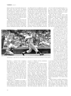
It is by these stern standards that the Pacific Crest Trail is judged to be an easy one. But on any day's ride you can count on traversing a number of high, narrow places—great scenic terrain like that at Dutch Miller Gap, where you can look from the headwaters of west-flowing rivers on one side of the divide to a necklace of tiny mountain lakes on the east, or the ridge above the famous hunting grounds of Big Crow Basin, where you can peer down through the top branches of 200-foot firs and watch herds of elk—a scenic spectacular that would be much more appreciated if the viewer were less concerned that this wonderful sight might be his last.
This is particularly the case if you are traveling with a packtrain and riding a surefooted mountain pony. Every mountain pony is surefooted, as every surefooted mountain guide will tell you. But if you happen to be following the Pacific Crest Trail and you happen to watch the hind legs of the pony ahead, you are likely to note a disquieting amount of skidding and bumping and clumping, places where a hoof is planted on the edge of a hole and hastily moved when the dirt slides and, from time to time, for no reason at all, a sort of sideways kick, like a misplaced Charleston dance step. Never mind. You will somehow negotiate these narrow places and you will always find, on the far side, a neat green-and-white, diamond-shaped enameled marker bearing a picture of a tree and the comforting words "Pacific Crest Trail System," evidence that even a government has been there before you. The signs are fastened on tree trunks or on solid posts planted deeply in the ground. You find them ranged evenly across a mountain meadow where there might be some question as to the point at which the trail, emerging from woods on one side, plunges into woods again on the other. They run through stands of immense spruces, patches of Alaska cedar and groves of featherleaf maple. They lead through country that has never been really mapped or explored, past unnamed lakes that have never been fished. At first these green-and-white diamonds in the forest gloom seem interesting because of the way they are placed, at every vague fork where a traveler might be perplexed as to which way to go or at a bend hidden by tree trunks that he might miss. After a time they become friendly and reassuring symbols of human communication in the wilderness. And eventually they become almost hypnotic, leading on and on into airy spaces of tranquil solitude, past an endless succession of cascading streams, heather meadows, serene snow peaks and limitless expanses of velvet-green treetops. Thus, if the trail is narrow, it is also scintillating; if it is demanding, it is also beckoning.
One of the trail's unique geographical advantages is that it is accessible to so many people. From Seattle to Snoqualmie Pass, the spot where this remarkable north-south footpath crosses the Northwest's main east-west highway, is only 48 miles. There the trail curves through the big trees along Commonwealth Creek, in which amber rocks and sizable trout are visible in water almost as clear as air—a long way from wilderness but still a silent woods, except for the rush of the water, as soon as the highway is left behind. The riding clubs of Tacoma can take off early in the morning, unload their horse trailers at Silver Creek and within 15 minutes be deep in the solitude of the Norse Peak Trail, which intersects the Pacific Crest Trail at Big Crow Basin. Near Portland the trail spirals around Mount Hood. It can be picked up as it crosses Oregon's main roads, and a highway runs parallel to it for much of the 400 miles that it follows the summit ridge of the Cascade Mountains. In California it is a network of loosely connected riding and hiking trails. One section passes within 20 miles of downtown Los Angeles before it turns east past Lake Arrowhead, curves south through the San Bernardino National Forest and Cuyamaca State Park and reaches the Mexican border.
So the trail has the increasingly valuable advantage of providing innumerable ways to the woods and wilderness. The chain of 22 national forests that runs down the Pacific coast covers some 20 million acres, and the trail is a dark-brown strip woven almost through the center of them.
The trail's recorded history begins with Clinton Clarke, a big, shaggy retired conservationist from Pasadena, Calif., who was married to an actress, was one of the sponsors of the Pasadena Playhouse and was an amateur playwright when he was not out hiking. In 1932 Clarke formally proposed to government officials that a continuous wilderness trail be traced from Canada to Mexico. There were great trails throughout the western states—the John Muir Trail in California, the Skyline Trail in Oregon and old, unmarked Indian paths in the Cascades in Washington—and plans to unify them into a system that would run all the way down the coast had often been discussed, especially after the Appalachian Trail was built in the East. Clarke knew about Russian trails and had learned that the Russians, who were reputed to be good woodsmen because of their enormous forests, were cutting wilderness paths in the mountains and training their young people to use them. He wrote that the U.S. should follow the same policy for the sake of physical fitness and national defense. Somebody must have agreed.
"The project was approved and adopted," he wrote, referring to himself in the third person, "and Mr. Clarke was placed in charge." (This was a little mysterious, for he was not connected with the Forest Service, which would have to lay out the trail.) Clarke then organized the Pacific Crest Trail Conference, appointed himself the head of it and began publishing books, maps and reports at his own expense.
Clarke believed in backpacking into the wilderness—no horses. He ridiculed the big, trail-riding, packhorse vacation trips organized by the Sierra Club, describing them as hordes of animals chewing up all the grazing land in order to move tons of equipment. He worked out meticulous lists of the absolute essentials a hiker had to carry (he got it down to 52 pounds for a two-week hike), and he incorporated a good deal of humane instruction in his literature. "Start hiking early, by 8 o'clock," he wrote. "Go slowly at first. Always rest by standing in the sun. (If you sit down you will lose pep.) Drink a little water, a raisin under the tongue will help." He never missed a chance to explain how you could identify the 130 kinds of flowers to be found along the Pacific Crest Trail, the nine species of trout, the 46 different animals and 86 birds. He also filled the files of the regional offices of the Forest Service with queries as to why more work was not being done on the trail. Government officials regarded him a little uneasily, but John Sieker, then a young forester, who now is the Forest Service's director of recreational land use, remembers calling on Clarke in Pasadena and being pleasantly surprised to find him quiet, persuasive and good-natured—"the sort of visionary who does a lot of good."
Clarke's rigorous publicity efforts—including relays of hikers hurrying from Mexico to Canada over the trail—ended with the war, which also stopped the work of Robert Marshall, then in charge of recreation in national forests and another key figure in the trail's history. Marshall was one of the most controversial of the extreme left-wing radicals in the early days of the New Deal. One of his brothers was the head of the Board of Education in New York City. Another was a radical economist and contributing editor of the magazine Soviet Russia Today. They were the sons of Louis Marshall, a celebrated constitutional lawyer, one of whose major cases was his successful argument before the Supreme Court on the constitutionality of federal laws protecting geese and ducks that migrated over state borders. Among innumerable other distinctions, the great lawyer was president of the New York; State College of Forestry of Syracuse University.
Young Robert Marshall—for whom the Bob Marshall Wilderness in Montana is named—graduated from the forestry college of Syracuse, got his doctorate in plant physiology from Johns Hopkins, worked as a ranger in Montana, wrote two bestselling books about his explorations in Alaska and became the first director of recreation for the national forests. President Roosevelt, who operated his own tree farm at Hyde Park, was interested in forest preservation, and Marshall's love of the wilderness was fanatical. In his view, wilderness areas were not merely to be kept from commercial exploitation, but from any use of any kind. They were to remain forever inaccessible, except by foot or on horseback. Marshall made no secret of his left-wing sympathies, but he did not want the masses in the woods. He claimed that the emotions of one solitary, courageous man who endured hardships to penetrate an untouched wilderness were more valuable than the casual sightseeing of millions. If the solitary individual faced risks and hardships in reaching his chosen solitude, so much the better. The Pacific Crest Trail was the kind of project Marshall approved of. What he might have made of it is speculative: he died of a heart attack shortly after the Nazi-Communist pact that preceded World War II—and the war stopped work on the trail.
The survey to trace the trail began in the summer of 1935. Five forest rangers, led by Nels Bruseth, an amateur botanist and landscape painter as well as a veteran of the Cascade forest, started south from Monument 78. Their instructions called for them to locate a wide, easy grade, to lay out the trail so that it passed through scenic country, to keep to the summit ridge, to note all wildlife, to check good hunting grounds and to test the fishing in streams and lakes. In their first eight miles, the rangers diligently reported later, they came upon a porcupine, a fool hen with chicks, a whistling marmot, 11 mountain goats and a herd of seven deer. They also saw a deer standing motionless in a meadow 200 feet below, trapped by four circling coyotes. When one of the rangers yelled to scare away the coyotes, he startled a bear that had been eating berries in the brush nearby. It was that sort of country and, with minor exceptions, it has remained much the same. Nobody is going to find as much wildlife near the trail now as the rangers found when they traced it along over dim Indian paths on the ridges in 1935, but the strange sense of wilderness, isolation and intimacy is as real now as it was then.
The official report of the survey consists of two large unpublished volumes, now preserved in the regional office of the Forest Service in Portland, that must rank among the strangest government documents ever written. They are filled with dazed poetry, oddly intermingled with dry, official prose. The rangers estimated that a permanent trail could be built for $545 a mile for the first 31 miles below the border, and added that "the view is wonderful, with scattered clumps of dark green alpine fir, twisted but sturdy pines, and mats of blossoming pink and white heather, the phlox creeping over rock and turf." They went on, day after day, fishing for rainbows in the public interest, seeing how many different species of trees they could identify along Agnes Creek (30) and measuring the diameter of cedars to find the biggest (15 feet through), meanwhile noting the taste of wild raspberries, the winelike flavors of blueberries in different regions and the precise spots where they had seen dozens of bears, a hundred or so goats and several hundred deer.
It was a hard, scrambling passage nevertheless, and it was not until they reached Stevens Pass, 188 miles south of the border, that they first hit civilization. They quickly reentered the wilderness, breaking out again at Snoqualmie Pass, 245 miles from Canada, and near the entrance of Mount Rainier National Park, at about mile No. 315. Aside from a few unimportant back roads, that was all until the Columbia River was reached, the end of their 457-mile march. The actual cutting of the trail began soon after, most of it being done by Civilian Conservation Corps workers. By 1937 it was open to the public and in use.
The trail is more crowded now than it was nearly 30 years ago, but "crowded" is one of those relative words, a verbal absurdity when one is talking in terms of forests and mountain ranges. Today's camper meets the trail at one of the countless highways that intersect it, turns his horse up a switchback that overlooks the asphalt and automobiles, turns once more and finds a world in which to lose himself, even as Nels Bruseth and his rangers did. The transition to wilderness is nearly instantaneous. The horses plod with their exaggerated, nodding-head movement, as if emphasizing that theirs is uphill work. When Theodore Winthrop rode this route near Naches Pass in 1853, he followed a dim Indian path until "the narrow trail plunged into thickets impenetrable but for its aid," a world "leagues above doubt and depression." Except for the green-and-white trail markers, there are no indications as to where you are. You orient yourself by common associations, so that a description of a place—"the curve by that big cedar snag"—is understandable only to someone who has been there. In the solitude of the trail, with the slow pace of travel and the clarity with which trees and boulders and even clumps of brush are imprinted on the memory, direction finders like these become appropriate. The directions of modern society, such as "Turn left at the next light" or "Keep in the center lane before the circle," begin to seem eerie and unreal.
A quarter of a century ago, when the rangers who were making the survey of the trail approached Mount Rainier from the north, they found "low grades through gentle slopes of open timber," and their description is still good; for much of the way you could use either this government report or Winthrop's Canoe and Saddle as a guidebook and not go far astray.
The trail in this area winds along a bench facing silver cliffs overhung with mountain greenery, overlooks tiny lakes (14 of them in 10 miles) and diminutive streams (27 of them in less than 10 miles) that flow down one side of the Cascade slope or the other, their headwaters a few hundred yards apart. The markers lead into great fields of timothy, blue grass and wild clover. Horses can make three miles an hour through the open country, but usually there is slow progress in such meadows. No one ever says he is tired, but someone says, "Isn't that a goat on that cliff over there?" or something equally arresting; the procession comes to a halt, glasses are brought out, the goat turns out to be a white rock and long discussions of natural history follow. By the time the riders arise from the soft grass, the horses are ready to go on.
Opinionated as they are, these mountain ponies have one good feature: they do not expect you to mount or dismount on the left side, a great convenience, for often there is not any left side to the trail. Riding south on the east slope, for instance, if you dismounted on the left you might plummet into some headwater of the Cle Elum River. Or riding north on the west slope, you might plunge into the gorge of a branch of the Snoqualmie and drain into Puget Sound. Since the Pacific Crest Trail is emphatically a ridge trail in this section, there is usually a slope on one side of it or the other and sometimes on both sides. When you face the problem of remounting, you find yourself standing by your horse with your eyes at the level of the stirrups. Some of these ponies will move alongside a big rock of their own volition in such cases and let you slide down into the saddle—the most endearing act, to a weary rider, to be found in the annals of horseflesh.
Wilder now, and darker, the trail rises, and Mount Rainier looms as an immense porcelain cone above the dark surge of the forest. It appears too high to be believed, a misplaced element, something belonging to the sky as much as to the earth. Wilder still, and more thrilling, the trail drops swiftly down to a level-floored primeval forest as dark as a cave. Here it becomes a pitch-black line of damp oily earth, bordered with moss, thick growths of fern and small jade-green plants with leaves like polished shells—a green-and-gray world, silent, secluded, forgotten since the beginning of time. Along Little Crow Creek, a short distance from the trail, there are elk tracks that cut deep into the dark soil, sometimes half a foot down in the soft earth. And sometimes on the opposite side of the creek there may be the crash and whirl of sound as these animals careen into deeper woods, a momentary embodiment of the wilderness, vanishing as soon as heard
Wilder even still, and darker, the trail vanishes into dripping woods, ceaselessly changing treescapes of huge columnar trunks. The lower branches of the big cedars, cut off from sunlight centuries ago, have long since died but have not fallen. They droop close to the trunks, gray and wirelike compared to the rich green foliage above and the dense undergrowth below. Dead, too, are scrawny, dry streamers of moss and trees that have been uprooted in storms, lying dried and whitened in the woods, their bonelike branches suggesting the museum skeletons of extinct monsters. Sometimes there are startling signs of some recent happening, a pile of bright, white sawdust and a freshly cut tree trunk where the rangers have cleared the trail with power saws after a storm. It is impossible to write of the Cascade forest without thinking of Winthrop's description of the elemental disquiet it creates: "From this austere wood there was no escape, passing forever between rows of roughhewn pillars, never penetrating into any shrine where sunshine entered.... "
Streaks of metallic light begin to show between the tree trunks—not overhead, for the foliage is too thick for that, but alongside, where sky and clouds become visible—as the trail runs near the edge of a cliff. The forest ends; the path comes out into daylight, into a world of gravel and grass and scattered lodgepole pine.
The Cascade Range is the sharpest climatic break on earth. On the west are cloudy skies, heavy rainfall, innumerable white-water rivers and the forests of Douglas fir that are almost solid growths 200 feet or more above the earth. East of the divide there are different cloud formations, coyotes instead of badgers, more camp robbers and hawks and fewer kingfishers and water ouzels, different flowers, little rain, massive cinnamon-red ponderosa pines growing in open glades and grass that gives way to sagebrush on the lower slopes. Sometimes the change can be seen within a quarter of a mile. Sometimes in a few minutes you can pass from blowing rain on the west side to bright sunlight and singing birds on the east.
Who uses the trail? In one day's riding you may meet bear hunters who are backpacking into the mountains to be ready for the opening of the season; a rancher who has taken his mare and her colt into the mountains so the colt will be accustomed to mountain trails almost from birth; a party from a riding club; boys with no equipment except their fishing tackle, who plan to sleep by a lake if they catch enough for a meal and to hike back to the highway if they do not; ornithologists studying hawks.
Near Olallie Lake in Oregon, a forest ranger who inspects the trail estimates that two big packtrains come through every week during the summer, with a few individual riders or pairs of riders a day, and an unknown number of hikers, perhaps a dozen or more daily, during weekends of good weather.
But if you try to find who uses the trail at Campo on the Mexican border, the most frequent reaction you will get is "What trail?" When Clinton Clarke planned the trail to start—or to end—at Campo, the old town was a bleached, dry desert post. It contained the barracks, an ancient stone store that had figured in border raids, a hotel on a hill that looked down upon the sagebrush on the Mexican side, and a depot for the wheezing San Diego & Arizona Eastern Railway Company, whose tracks wander drunkenly from one side of the border to the other. Clarke thought of Campo as a romantic and historic town, as different as possible from the forest terminal of the trail in the North. But the cavalry post has long been closed. The barracks have become a school. The hotel burned. Travelers at Campo these days are more likely to be calling during visiting hours at the big reformatory on the edge of town than starting a hike to Canada.
One reason so few hikers see Campo is that the pattern of use of the entire trail is changing. The heroic trips that Clarke visualized have become rare, although wherever you stop you hear of some dedicated spirit who set out several years ago for either Mexico or Canada. At the Crest Trail Inn, a little restaurant on the Columbia River where the trail emerges after skidding down a slope, the proprietor has kept an unofficial record of such long-distance followers of the trail: a young fellow who had walked from Campo, rejoicing that he had only 457 more miles to go to Monument 78; a handsome young couple who were dawdling south from Canada and expected to reach the Mexican end of the trail in two more years. "I have often wondered," he said, "what happened to them."
If the long trips have become infrequent, the short ones have greatly increased. More and more riders are taking their horses by trailer to some point where the trail meets a road and riding to another road-crossing a few days away. The average walking trip on the trail is now about 25 miles, because that is the usual length of an overnight outing, which keeps the weight of the load to be carried by a hiker or a pair of hikers to the minimum. For that matter, there was often something forced about the attempt to picture the trail as spanning the nation from north to south. Conditions on it varied too greatly. In northern California there was a 100-mile stretch over back roads. In the High Sierras there were places recommended only for expert mountaineers with proper equipment, with five mountain passes above 12,000 feet.
The changes in the use of the trail indicate another problem about it. In the East, the 2,000-mile Appalachian Trail from Maine to Georgia was built by the private effort of hiking and climbing clubs along the way, a procedure that practically insured that there would be good and bad stretches, depending on how industrious the local hikers were. But it also insured that a great many people would have a vested interest in it and a concern for what happened to it. The Pacific Crest Trail is a government project, meaningless without the national forests that enclose it. If it is kept up to a high standard by the rangers, it is also entirely in their hands, with no local bodies more than remotely concerned with its upkeep. Finally, its usefulness—indeed, its very existence—is dependent on the policy of the government about timber cutting in the national forests. Clarke tried hard to have a 10-mile-wide strip of forest set aside, so that the trail route would remain in its natural condition, even if portions of the national forest were logged. But he failed.
One result is that the condition of some small areas of the trail has changed. You may find the most beautiful forest grove in the world one summer and, when you try to return to it the next, discover it has been chewed to pieces and the hills cut down to yellow clay. Since 1955 the amount of logging permitted in national forests has jumped from 6 billion board feet to 9 billion board feet a year, and cutting has been particularly heavy in the forests where the trail runs through Oregon and Washington. Perhaps this is one more reason why lengthy trips over the Pacific Crest Trail have become rare.
But actually the appeal of this north-south route is not that it leads to Canada or Mexico. Its glory is that it leads nowhere at all. It is a sort of multimillion-acre invitation to dawdle and loaf, to stretch out in the grass and sleep or stop at the next lake and fish. It is a track through a trackless forest; a road that is its own reason for being, not one that has a destination. Those green-and-white trail markers only point the way toward ferns and trees, blackberries and raspberries, hawks and eagles, brooks and streams, elk herds and mountain goats. They are small green signposts leading to and through a magnificent world.
TWO PHOTOS
JACK FIELDS
MAP
Twenty-two national forests enclose the Pacific Crest Trail in an unbroken chain of wilderness wonders.
PACIFIC OCEAN
WASH.
ORE.
NEV.
CALIF.
Monument 78
Seattle
Tacoma
Olympia
Mt. Ranier
Portland
Mt. Hood
Crater Lake
Mt. Shasta
Sacramento
Reno
Lake Tahoe
San Francisco
Mt. Whitney
Los Angeles
Campo
MAJOR HIGHWAYS
PACIFIC CREST TRAIL
FOREST PRESERVES
PHOTO
JACK FIELDS
View near Big Crow Basin in the Cascade Mountains, where Don Ralston and his family pause on the crest ridge, is typical of trail scenery.